
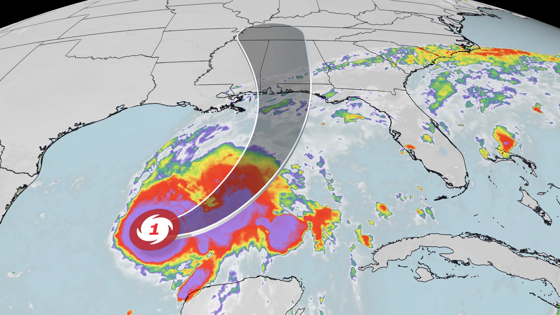
Communities across the northern Gulf Coast are finalizing emergency preparations as Hurricane Isaias advances toward an expected weekend landfall near the Alabama-Florida border. After rapidly gaining strength over record-warm ocean waters, the storm presents a multi-hazard threat characterized by dangerous coastal storm surge, widespread flooding downpours, and severe wind gusts. State officials in both Florida and Alabama have declared states of emergency, initiating mandatory evacuations in vulnerable coastal areas and triggering widespread shutdowns across public transit, regional airports, and school systems.
Forecast models indicate that while the storm may experience slight structural changes prior to reaching land early Saturday morning, its overall impact zone will remain extensive. Local authorities are urging residents to take weather warnings seriously and complete all property safeguards, as hazardous condition windows begin closing rapidly by Friday afternoon.
Storm Dynamics: Rapid Intensification, Atmospheric Shear, and Risk Expansion
Hurricane Isaias demonstrated rapid intensification earlier in the week when its wind speeds jumped from 35 mph to 70 mph within a single 24-hour window from Tuesday night into Wednesday night, reaching the threshold that defines rapid intensification. The system officially became the first hurricane of the Atlantic season on Wednesday evening. Meteorological tracking showed sustained winds reaching 85 mph as the cyclone moved across the Gulf of Mexico, with forecasts projecting a peak as a high-end Category 2 storm with 110 mph winds before approaching the coast.
As Isaias approaches the United States coastline, it is expected to encounter atmospheric wind shear and patches of dry air. While wind shear typically disrupts a tropical system’s core and can cause minor overall weakening, meteorologists warn that this interaction will push the highest wind and rain activity to the northern and eastern sides of the storm. This lopsided structure effectively broadens the footprint of hurricane-force winds, exposing a wider geographic area to severe weather conditions than a compact, highly symmetrical hurricane would impact.
If Isaias maintains hurricane status through landfall, it will represent the first hurricane to strike the United States mainland in two years, following Hurricane Milton’s Category 3 landfall on Florida’s Gulf Coast in October 2024. Isaias is already the fourth named storm to make US landfall this season, following tropical storms Arthur, Bertha, and Edouard.
Coastal Hazards: Severe Surge, Inland Rain, and Severe Weather Threats
One of the primary threats posed by Hurricane Isaias along the shoreline is coastal storm surge, forecasted to reach up to 7 feet in peak areas. The northern Gulf Coast is uniquely vulnerable to storm surge due to its underwater bathymetry; the shallow ocean floor near the coast acts as a ramp, allowing powerful winds to pile up seawater and push it inland. Official storm surge warnings now stretch across a vast coastal line, from the mouth of the Mississippi River in southeastern Louisiana all the way to the Suwannee River in Florida’s Big Bend region.
In addition to rising waters from the ocean, heavy tropical rainfall threatens coastal and inland communities alike:
- Mobile and Gulf Shores, Alabama: Expecting peak impacts from late Friday afternoon through Saturday morning. High tide hits around 10:00 p.m. ET Friday. Rainfall estimates range between 6 and 10 inches, accompanied by wind gusts reaching 80 to 100 mph during late Friday night.
- Pensacola, Florida: Anticipating heavy weather peaking late Friday into Saturday, with 6 to 10 inches of rain and hurricane-force gusts starting around 9:00 p.m. ET Friday. High tide occurs around 11:00 p.m. ET Friday.
- New Orleans, Louisiana: Expecting lighter impacts, with around 1 inch of rain starting Friday morning and wind gusts topping out between 35 and 45 mph.
Beyond rain and surge, atmospheric moisture transported by Isaias’ outer rainbands will create conditions favorable for isolated, short-lived tornadoes. The Storm Prediction Center has identified a Level 2 out of 5 risk for severe thunderstorms and tornadoes stretching from Mobile, Alabama, to Tallahassee, Florida. Farther inland, parts of the southern Appalachians could receive 3 to 5 inches of rainfall on Saturday. However, weather analysts note that Isaias’ relatively fast forward speed should prevent the extreme, multi-day rainfall totals seen during Hurricane Helene earlier in the season.
Evacuations, Transportation Delays, and Institutional Shutdowns
Local and state governments have enacted mandatory measures to move citizens out of harm’s way. In the Florida Panhandle, mandatory evacuation orders are active for specific zones in Gulf and Okaloosa counties, while Walton County has issued voluntary evacuation advisories for low-lying areas. Florida Governor Ron DeSantis placed 25 counties under a state of emergency, while Pensacola Mayor D.C. Reeves declared a citywide emergency. In Alabama, Gulf Shores Mayor Robert Craft requested mandatory evacuation authority from state management agencies to prevent gridlock on local getaway routes, while maintaining voluntary evacuations for non-residents.
Transportation and infrastructure networks across the region are undergoing widespread adjustments ahead of the storm:
- Airports: Pensacola International Airport will close its terminal to commercial flights on Friday morning, with runway operations shutting down completely at 6:00 p.m. Friday. Airports across Okaloosa County, including Destin-Fort Walton Beach, suspended operations on Thursday evening.
- Rail Services: Amtrak cancelled all Mardi Gras Service line trains running between New Orleans and Mobile through Sunday due to storm floodgate operations in New Orleans. The Crescent line between New Orleans and Atlanta is also suspended, with normal schedules anticipated to resume Monday.
- Education and Local Government: Public school systems in Mobile County and Baldwin County in Alabama canceled all classes for Friday, along with weekend extracurricular activities. At least 14 counties across the Florida Panhandle closed schools, and Florida State University suspended operations at its Panama City campus. Local government administrative offices in Escambia, Okaloosa, Washington, and Calhoun counties were closed heading into the weekend.
- Major Events: ESPN announced that its College GameDay broadcast for the matchup between Georgia and Alabama in Tuscaloosa will shift indoors to the Coleman Coliseum on the University of Alabama campus, prohibiting overnight spectator camping due to incoming severe weather. Kickoff for the game remains set for Saturday evening.
With storm conditions expected to deteriorate quickly on Friday afternoon, emergency officials recommend that all storm preparations, supply gathering, and coastal evacuations be completed prior to the arrival of tropical-storm-force winds.