
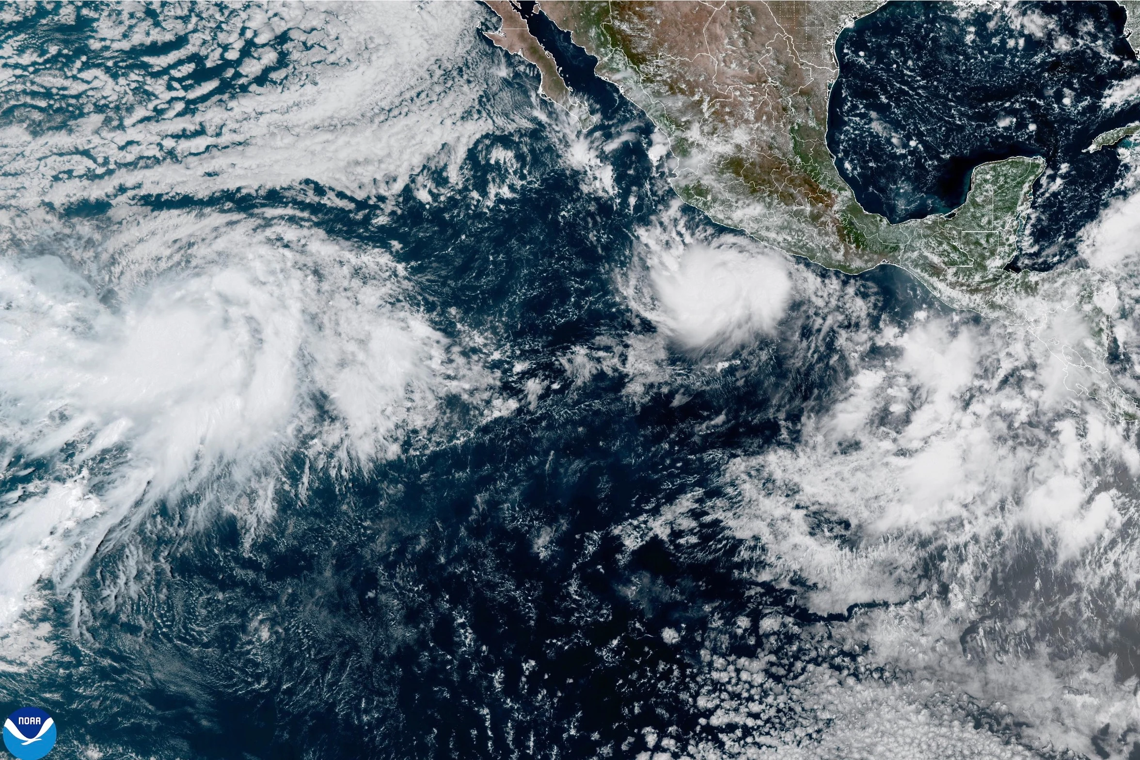
An extraordinary surge in tropical power has produced one of the most formidable Pacific cyclones recorded in recent decades. Hurricane Polo achieved Category 5 status off the southwestern coast of Mexico, carrying maximum sustained winds of 165 mph (265 kph) as it churned over open waters. The rapid transformation over a 24-hour window has drawn intense scrutiny from meteorologists and triggered widespread emergency preparations across coastal communities.
According to updates from the National Hurricane Center (NHC) in Miami, the storm sat roughly 210 miles (338 kilometers) south of Zihuatanejo, Mexico, remaining nearly stationary late Tuesday night. While forecasts indicate the cyclone is unlikely to make direct landfall, its massive wind field and heavy rainfall present substantial hazards to several western Mexican states.
Coastal Impact and Emergency Response Across Southwestern Mexico
Mexican President Claudia Sheinbaum confirmed that meteorological models project Polo will skirt the coastline rather than push directly inland. Nevertheless, weather officials emphasize that direct landfall is not required to cause catastrophic damage. Hurricane-force winds extend up to 40 miles (65 kilometers) from the storm’s center, while tropical storm-force winds stretch outward up to 105 miles (169 kilometers).
Authority figures across the region have initiated preventive safety protocols. Port operations were suspended by the Mexican Navy in the states of Guerrero and Michoacán, with explicit warnings issued to maritime workers, commercial fishermen, and coastal residents. Local authorities also suspended school classes across multiple vulnerable districts on Tuesday.
Forecasts call for widespread rainfall totals between 3 and 6 inches (8 to 15 centimeters) across Guerrero and Michoacán, alongside lighter accumulations along the coastal stretches of Oaxaca, Colima, and Jalisco. Meteorologists warn that such heavy rain on saturated coastal terrain creates high risks of flash flooding and destructive mudslides.
In municipal hubs like Lázaro Cárdenas, Michoacán, business operators scrambled to secure structures against incoming surf. Local seaside restaurant owner Concepción López Villegas expressed deep concern as ocean waves began pushing high onto the beach front, noting that years of community heritage and personal investment face immediate risk from pounding waves.
Safety advisories extend to foreign nationals as well. The U.S. Embassy in Mexico published an official weather alert urging citizens to keep clear of ocean waters and beaches, pointing out that intensified ocean conditions generate lethal rip currents and unpredictable rogue waves regardless of direct landfall.
Atmospheric Dynamics Behind the Rapid Intensification
The speed at which Polo intensified caught weather monitoring agencies off guard. Reports from the NHC described the storm’s overnight power build as truly remarkable. Polo now stands as the third Category 5 hurricane to emerge in the Pacific basin this season, following earlier superstorms Genevieve and Lowell. Saffir-Simpson scale benchmarks define Category 5 hurricanes as storms maintaining winds higher than 157 mph (253 kph).
Atmospheric researchers tie this wave of intense activity directly to global climate patterns. Philip Klotzbach, a research scientist in the Department of Atmospheric Science at Colorado State University, pointed to the ongoing El Niño phenomenon as the primary catalyst. In the Pacific Ocean, El Niño alters atmospheric wind patterns and raises sea surface temperatures, providing ideal thermal energy for cyclones to develop rapidly.
Kristen L. Corbosiero, a professor in the Department of Atmospheric & Environmental Sciences at the University at Albany, noted that Polo ranks among the strongest storms ever documented within the Pacific Basin. Historical data maintained by the NHC indicates Polo’s wind velocity is comparable to only a handful of past Pacific events, most notably Hurricane Patricia in 2015, which reached peak winds of 215 mph (346 kph).
The Pacific-Atlantic Seasonal Contrast
The intense activity in the Pacific stands in sharp contrast to conditions in the Atlantic Ocean. While the Pacific has generated three Category 5 storms this year, the Atlantic basin set a record for its longest start to a hurricane season without a single named hurricane forming.
This stark divergence is a classic hallmark of El Niño. While warm waters and low wind shear fuel rapid cyclone expansion across the Pacific, the same atmospheric phenomenon generates strong upper-level wind shear across the Atlantic basin, effectively disrupting storm formation before systems can organize.
Polo is projected to execute a slow but sharp turn toward the northwest, eventually steering on a general west-northwestward track over the coming days. Coastal populations throughout Guerrero, Michoacán, and Colima remain under tropical storm warnings as the system continues to generate heavy seas and severe rain bands along Mexico’s Pacific littoral.